Wild & Scenic Rivers Act 50th Anniversary

by Ben Costello, April 2018
![]()
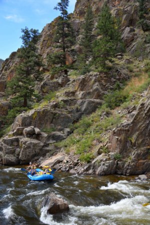
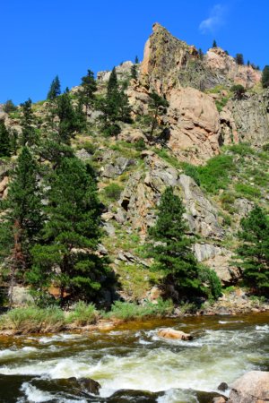
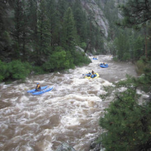
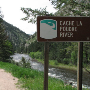
2018 marks the 50th anniversary of the Wild & Scenic River Act which was enacted by Congress on October 2, 1968. The anniversary of this landmark legislation brings the opportunity for us to celebrate wild, free-flowing rivers and the impact that these rivers have on our lives. We are very fortunate in Fort Collins, that we live next to the only Wild & Scenic River in Colorado, the Cache La Poudre. The Poudre River is near and dear to many in Northern Colorado. I believe it is the lifeblood of our community and our most important natural resource. Let’s take time in 2018 to celebrate the Cache La Poudre, spend time in or near its waters, and make sure we truly understand how positively it impacts our wellbeing.
The Wild & Scenic River Act
The Wild & Scenic Rivers Act is an extremely important piece of legislation because it protects the character of our best free-flowing rivers. Free-flowing rivers are the most healthy ecologically of any river systems and provide for the most impactful recreational experiences. The act allows for management of the rivers for public enjoyment and prevents the rivers from being dammed. It also promotes public involvement in setting goals for rivers while also promoting management that crosses over political boundaries.
Section 1, (b) of the “Wild and Scenic Rivers Act” states, “It is hereby declared to be the policy of the United States that certain selected rivers of the Nation which, with their immediate environments, possess outstandingly remarkable scenic, recreational, geologic, fish and wildlife, historic, cultural, or other similar values, shall be preserved in free-flowing condition, and that they and their immediate environments shall be protected for the benefit and enjoyment of present and future generations.”
Section 2 (b) of the “Wild and Scenic River Act” states rivers “shall be classified, designated, and administered as one of the following:
- (1) Wild river areas – Those rivers or sections of rivers that are free of impoundments and generally inaccessible except by trail, with watersheds or shorelines essentially primitive and waters unpolluted. These represent vestiges of primitive America.
- (2) Scenic river areas – Those rivers or sections of rivers that are free of impoundments, with shorelines or watersheds still largely primitive and shorelines largely undeveloped, but accessible in places by roads.
- (3) Recreational river areas – Those rivers or sections of rivers that are readily accessible by road or railroad, that may have some development along their shorelines, and that may have undergone some impoundment or diversion in the past.”
The Wild & Scenic Rivers System
Today, the National Rivers System protects 12,734 miles of 208 rivers in 40 states and the Commonwealth of Puerto Rico. This is less than one-quarter of one percent of the nation’s rivers. By comparison, more than 75,000 large dams nationwide have modified at least 600,000 miles, or about 17%, of American rivers.*
Key Facts:
1. Designation as a Wild & Scenic River does not prohibit development or give the federal government control over private property. Recreation, agricultural practices, residential development and other uses can continue (See detailed FAQs here).*
2. Rivers, or sections of rivers that are designated as ‘Wild’, ‘Scenic’, or ‘Recreational’ are protected through voluntary stewardship by landowners and river users, and through regulation and programs of federal, state, local or tribal governments.*
3. Not all land within the boundaries of designated rivers is, or will be, publicly owned, and the Act limits how much land the federal government is allowed to acquire from willing sellers.*
4. The Act strives to balance dam and other construction at appropriate sections of rivers with permanent protection for some of the country’s most outstanding free-flowing rivers. To accomplish this, it prohibits federal support for actions such as the construction of dams or other in-stream activities that would harm the river’s free-flowing condition, water quality or ‘outstandingly remarkable’ resource values.*
5. Designation does not affect existing water rights or the existing jurisdiction of states and the federal government over waters as determined by established principles of law.*
The Wild & Scenic Cache La Poudre River
On October 30, 1986, portions of the Cache La Poudre River were designated for protection under the Wild & Scenic Rivers Act. The State of Colorado has approximately 107,403 miles of river, of which 76 miles are designated Wild & Scenic. That is less than 1/10th of 1% of the state’s river miles. All 76 of those designated river miles are found in the Cache La Poudre watershed. The main stem of the Poudre from its source at Poudre Lake to Hewlett Gulch Bridge is protected, as well as the South Fork of the Poudre from its source to the confluence with the main stem. 30 miles of the 76 designated miles are considered ‘Wild’ while the remaining 46 miles have a ‘Recreational’ designation.
Referrences & Resources
– Wild & Scenic Rivers 50th Anniversary Website, https://www.rivers.gov/wsr50/index.php
– 5,000 miles. 5,000 stories. One Unified Voice for our Nations Rivers, https://www.5000miles.org
– Wild & Scenic Rivers Flicr page, https://www.flickr.com/photos/wild_rivers/
– Cache La Poudre River “Wild & Scenic River” Map, https://www.rivers.gov/rivers/cache-la-poudre.php
*from Wild & Scenic River Act 50th Anniversary press kit, http://wsr50.onlinepresskit247.com